Skip to content
Cong Wang

Cong Wang

Designer | GIS Technician | Environmentalist | Urban Analyst

Menu
  • Activities
  • Collections
    • GIS Project
    • Landscape Project
    • Map Design
    • Technical Drawing
    • Academic Poster
    • Case Study
  • Skills
    • Analytical Skills
    • Data Visualization
    • ArcGIS
    • Adobe Creative Cloud
    • 3D Visualization
    • Teamwork
    • AutoCAD
    • Landscape Design
    • Landscape Planning
    • Planting Design
    • Image Analysis
    • Technical Drawing
  • Experience
    • Undergraduate Work
    • Postgraduate Work
    • Extracurricular Work

Skill: Analytical Skills

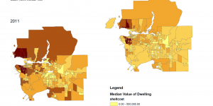
Quantitative Data Classification and Housing Affordability

The classification of quantitative data in an extremely important process in GIS. This lab includes two maps which involve quantitative data classification and housing affordability in the Greater Vancouver Area.


Vancouver Flood Risk Analysis: Identifying Tsunami Danger Areas

In this scenario, I was assigned as a GIS analyst with Metro Vancouver. I was assigned to create a series of maps that highlight the areas in the Metro Vancouver that are at risk of flooding or a storm surge.


Posts navigation

Newer posts
Brought to you and supported by UBC Arts ISIT


TERMS OF SERVICE