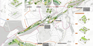
The project aims to develop a strategic planning proposal for the River Sheaf Catchment in Sheffield, which is currently under appreciated due to flooding, vacancy and habitat fragmentation. To address these issues and the demand for urban expansion, this project seeks to find a balance between urban and nature, and select areas for five thousand new housing and a minimum of 5% increase in new woodland to restore habitat, together with mitigate and adapt to flooding.
There are two phases of the project. Phase 1 focused on the survey and analysis using ArcGIS, while phase 2 aimed to propose a planning strategy to allocate 5000 new housings and increase 5% of new woodland.
As one of the memeber of the group, I contributed to the GIS analysis, strategic plan, analysis diagram, the model, one of the sections and one of the illustrations.
Phase One


Phase two


