Objective:
Produce a multi-criteria elevation (MCE) model to help direct the botanist’s search for potential habitats for a rare species, Spiranthes diluvialis, given a set of criteria for the preferred living conditions which are low-slope, mid-elevation areas with a southern aspect, and approximately 700 hectares.
Procedure:
In order to create the final map, the provided elevation, water, and transportation shapefiles were converted into feature classes to construct a TIN and a DEM, and then being examined using a multi-criteria evaluation (MCE) model by factor identification, data normalization, and multi-criteria analysis. The ideal habitat factors were normalized by determining an ideal value within a range of reclassified values. Elevation was normalized about 650 meters, slopes around ‘low’ and 180° south for aspect. Values close to the ideal parameters were reclassified close to 1 and otherwise, closer to 0. The normalized data was examined by weighted importance in two MCE models, which was calculated using the analytical hierarchal approach (AHP) calculator: see Fig. 1.
Multi-Criteria Evaluation Results:
The first MCE model (MCE33) assumes equally weighted importance, assigning each factor 0.33 of importance. The second MCE model (MCEWtd) shows an unequal weighted comparison where aspect (0.6) is slightly more important than slope (0.2) and elevation (0.2). The weighted sum for the MCE (MCE_comp) shows areas of overlap between infinite combinations of equally and unequally weighted comparisons. This is important when we consider how the spatial variability of potential habitats changes when the weighted importance varies.
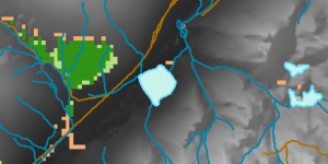
Figure 2. shows that there are three types of elements in MCE_comp: MCE weighted result (orange): 260 hectares, MCE33 result (light green): 247.25 hectares, and MCE weighted and MCE33 overlapping (dark green): 469.75 hectares, which should be the surveyed.

Figure 1. Equally and unequally weighted importance comparison using AHP calculator

Figure 2. Zoomed-in view of the area (x: 1467445; y: 469530)

Figure 3. DEM of water system in Southern Okanagan Valley

Figure 3. Final Map showing potential distribution of Spiranthes diluvialis